Crossing Canada isn’t about having the perfect vehicle; it’s about mastering the logistical challenges that standard travel guides miss.
- Fuel costs aren’t uniform; they’re a strategic game of provincial tax differences that can alter your budget by 30%.
- Your biggest risks aren’t other drivers, but vast resource gaps—hundreds of kilometres with no fuel, no cell service, and no help.
Recommendation: Shift from a tourist’s mindset to a logistician’s. Plan for contingencies, not just destinations, to conquer the highway.
You’ve seen the photos: the turquoise lakes of Banff, the rugged shores of Lake Superior, the endless sky over the Prairies. The call of the Trans-Canada Highway, a 7,800-kilometre ribbon of asphalt stretching from St. John’s, Newfoundland to Victoria, British Columbia, is powerful. It’s the ultimate Canadian pilgrimage. So you start planning. The internet tells you to get an oil change, check your tire pressure, and pack some snacks. This is good advice, but it’s dangerously incomplete. It prepares you for a road trip, not for this.
Listen up. I’ve driven this beast more times than I can count, in every season, behind the wheel of a big rig. The Trans-Canada isn’t a single road; it’s a series of distinct operational theatres, each with its own rules and its own ways of breaking the unprepared. The real challenges aren’t found on a mechanic’s checklist. They are the fuel price cliffs between provinces, the cellular dead zones that swallow you whole for hours, and the profound, hypnotic emptiness of the plains that can lull any driver into a dangerous trance.
Forget what you think you know about road trips. To conquer this journey, you need to stop thinking like a tourist and start thinking like a logistician. This isn’t about the best car; it’s about the best-prepared driver with a sound operational plan. This guide will give you that plan. We’re going beyond the basics to cover the strategic realities of fuel management, seasonal hazards, remote breakdown protocols, and calculating the true, unvarnished cost of the journey.
This article provides a strategic overview for tackling the Trans-Canada Highway. Below is a summary of the key logistical challenges we will deconstruct to ensure your coast-to-coast journey is a success, not a story of survival.
Summary: A Strategic Guide to Conquering the Trans-Canada Highway
- Why Your Gas Budget Will Vary by 30% Between Alberta and BC
- Northern Ontario Crossing: The 3 “Dead Zones” Where You Must Fill Up
- Highway Hypnosis: 5 Techniques to Stay Alert Across the Prairies
- Summer vs. Shoulder Season: When is the Trans-Canada Highway Actually Construction-Free?
- What to Do If You Break Down 200 km from the Nearest Town in Northern Ontario?
- The 300 km Gap: Where to Fuel Up on the Dempster Highway to Avoid Stranding
- The Gas Station Diet: How to Find Real Food on the Trans-Canada Highway?
- How to Calculate the Real Cost of a 2-Week Road Trip in Canada?
Why Your Gas Budget Will Vary by 30% Between Alberta and BC
The single biggest rookie mistake is assuming a flat rate for fuel costs. The price at the pump is not a simple matter of market forces; it’s a battlefield of provincial and municipal taxes. Crossing a provincial border can feel like entering a different country in terms of fuel cost. The most dramatic example is the leap from Alberta to British Columbia. Filling your tank in Calgary versus Vancouver can mean a difference of 30 cents per litre or more, which adds up to a significant sum over thousands of kilometres.
This variance isn’t random. It’s a complex mix of provincial fuel taxes, federal and provincial carbon taxes, and, in some cases, specific transit levies. For example, a significant portion of the higher cost in BC’s Lower Mainland is due to the 18.5 cents per litre additional transit tax for the Metro Vancouver area. Alberta, on the other hand, has a variable fuel tax that can drop to zero when oil prices are high, creating a massive price gap at the border. Understanding this isn’t just about saving a few bucks; it’s a core part of your trip’s logistical budget.
The following table breaks down the approximate tax burden in several key provinces. Use it not just as information, but as a strategic tool to plan your major fill-ups.
| Province | Total Tax Component (cents/litre) | Key Additional Charges |
|---|---|---|
| Quebec | 45+ | Cap-and-trade carbon pricing (~13¢/L) |
| British Columbia | 40-58.5 | Vancouver transit tax (18.5¢/L) |
| Ontario | 32-35 | Federal carbon tax (14.31¢/L) |
| Alberta | 28-35 | Variable fuel tax (0-13¢/L based on oil prices) |
| Manitoba | 28.9 | Lowest tax burden |
Northern Ontario Crossing: The 3 “Dead Zones” Where You Must Fill Up
The stretch of Highway 17 along the northern shore of Lake Superior is arguably the most beautiful and the most perilous section of the entire Trans-Canada. This is the Canadian Shield in all its rugged, unforgiving glory. The problem here isn’t traffic; it’s the profound emptiness. This region contains what I call “resource gaps”—vast distances where fuel, cell service, and amenities simply cease to exist. You are on your own.
There are three critical “dead zones” where you must be vigilant about your fuel gauge: Wawa to Sault Ste. Marie, Nipigon to Wawa, and Kenora to Dryden. The distances between stations can easily exceed 200-250 km. Never, ever let your tank drop below half in Northern Ontario. A sign that says “Next Services 150 km” means exactly that, with nothing but rock, trees, and moose in between. This is compounded by huge mobile dead zones, where your phone becomes a useless brick. In these areas, a satellite messenger is a lifeline, not a luxury.
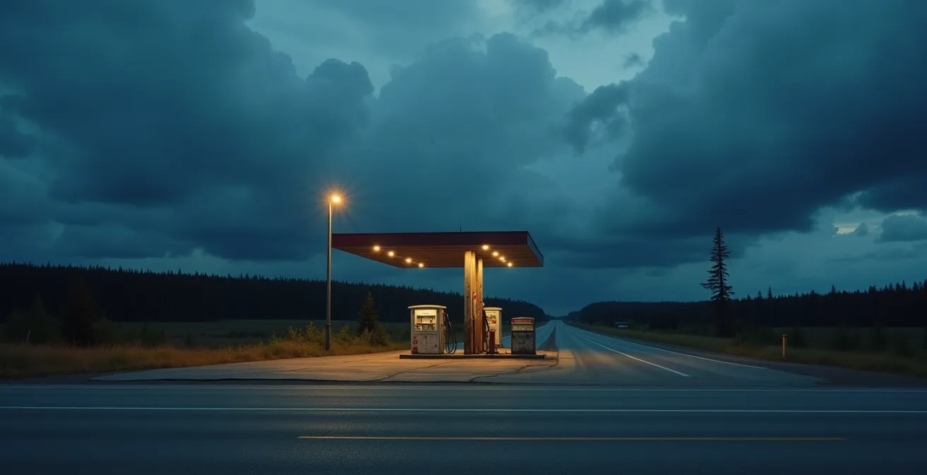
The isolation pictured above is not an exaggeration; it is the reality of the Northern Ontario crossing. Your vehicle’s reliability is paramount, but your self-sufficiency is what will truly get you through. Before entering this stretch, ensure you have a survival kit that goes beyond the basics. Think less about convenience and more about genuine self-rescue.
Your kit must include:
- Offline maps for the entire region (MAPS.ME or Gaia GPS).
- A satellite messenger device like a Garmin inReach or ZOLEO.
- A high-quality bug jacket for the notorious black fly season (May-August).
- Bear spray (and the knowledge of how to use it).
- A robust emergency food and water supply for a minimum of 72 hours.
Highway Hypnosis: 5 Techniques to Stay Alert Across the Prairies
After the winding roads of Northern Ontario and before the majestic climb of the Rockies, there are the Prairies. For hundreds of kilometres through Manitoba and Saskatchewan, the Trans-Canada becomes a dead-straight line aimed at the horizon. The sky is enormous, the land is flat, and the road never turns. This is the prime breeding ground for a dangerous phenomenon truckers know well: highway hypnosis. It’s a trance-like state where you are technically awake and driving, but your brain has checked out. You lose track of time and your reaction speed plummets.
Fighting this mental fatigue is just as important as any mechanical check. The key is to actively break the monotony and keep your brain engaged. Forget just chugging coffee; you need a proactive strategy. The sheer, unchanging scale of the drive requires a mental toolkit to stay sharp. High-profile vehicles also face the added challenge of persistent crosswinds that demand constant steering correction, adding to driver fatigue.
Here are five proven techniques to combat highway hypnosis and stay alert across the plains:
- Schedule Micro-Adventures: Intentionally plan stops at quirky roadside attractions. Mac the Moose in Moose Jaw, the World’s Largest Perogy in Glendon, or the giant cow in St-Claude are not just photo ops; they are critical mental resets.
- Rotate Drivers Frequently: On these long, straight stretches, switch drivers every two hours, without exception. This rule is ironclad for professional drivers for a reason.
- Engage Your Brain, Not Just Your Ears: Music can become part of the drone. Switch to engaging podcasts or audiobooks. CBC’s “Under the Influence” or “The Backbench” are excellent for keeping your mind actively processing information.
- Practice Active Scanning: Consciously move your eyes every few seconds. Check your mirrors, scan the horizon, look at your gauges, and then back to the road. Don’t let your gaze lock onto the vanishing point.
- Plan for Early Arrivals: Avoid driving into the late evening. Fatigue peaks at dusk, and the beauty of a prairie sunset is best enjoyed from a stationary position. Aim to be at your destination by 6 PM.
Summer vs. Shoulder Season: When is the Trans-Canada Highway Actually Construction-Free?
There are two seasons on the Trans-Canada: winter and construction. Finding a truly “construction-free” window is a myth. The real goal is to choose the season with the most predictable challenges. Your choice between summer and the “shoulder seasons” (late spring, early fall) is a trade-off between two different kinds of delays and dangers.
Summer (June-September) is peak travel season for a reason: the weather is generally reliable. However, this is also when road crews work frantically to repair the damage from the previous winter. You will face significant construction delays, especially in the mountain passes of BC and Alberta and across Northern Ontario. According to travel data, June to September brings intensive construction in Northern Ontario, with single-lane sections and pilot cars being common. These aren’t minor slowdowns; they can add hours to your driving day.
Shoulder Seasons (May, October) offer a tempting alternative with fewer crowds and less active construction. However, they come with their own set of hazards. The primary risk in spring is “frost heave,” where the freeze-thaw cycle buckles and breaks the pavement, creating bone-jarring potholes and uneven surfaces that can easily damage a tire or suspension.

The image above shows the reality of a spring road surface. Furthermore, mountain passes can still experience surprise snowstorms in May or October, leading to sudden closures. Before any leg of your journey, regardless of season, checking the provincial 511 road condition services is not optional; it’s a mandatory part of your daily pre-trip inspection.
- British Columbia: Check DriveBC for mountain pass conditions and avalanche control work.
- Alberta: Monitor Alberta 511 for construction in the Rockies.
- Ontario: Use Ontario 511 religiously for Northern Ontario delays.
- Manitoba: Check Manitoba Highway Conditions for reports of frost heaves in spring.
- Quebec: Review Quebec 511, especially around the Victoria Day long weekend when projects often kick off.
What to Do If You Break Down 200 km from the Nearest Town in Northern Ontario?
Let’s be blunt: a breakdown on a busy urban highway is an inconvenience. A breakdown in a cellular dead zone in Northern Ontario is a genuine survival situation. A pre-trip mechanical inspection is vital, but even the most reliable vehicle can fail. Your roadside assistance plan and your personal preparedness are what will make the difference between a long, expensive day and a potentially dangerous multi-day ordeal.
First, understand the limitations of standard roadside assistance. Basic plans often have towing limits of 10-20 km. In Northern Ontario, the nearest garage could be 200 km away. You absolutely need a premium plan like CAA Plus or Premier, which offer extended towing distances of 200 km or more. Second, you cannot rely on your cell phone. As we’ve established, there are vast stretches with no service. Contacting for help becomes the first and biggest hurdle.
This is where your logistical planning pays off. Having the right tools and knowing the protocol is critical. If you find yourself stranded, stay with your vehicle and activate your pre-planned emergency procedure. Do not attempt to walk for help.
Your Remote Breakdown Action Plan
- Initiate Contact: Immediately activate your satellite communication device (Garmin inReach, ZOLEO) to contact the Ontario Provincial Police (OPP) or your emergency contacts with your precise GPS coordinates. If you don’t have one, try to flag down a commercial truck; many drivers carry satellite phones and are part of a professional network that looks out for stranded motorists.
- Assess Your Resources: Take stock of your 72-hour emergency kit. Ration your food and water. Determine your ability to stay warm (or cool) in the vehicle.
- Verify Your Location: Use your pre-downloaded offline maps to confirm your exact location and the distance to the nearest communities in either direction. This information will be vital when you communicate with recovery services.
- Signal for Visibility: Turn on your hazard lights. If it is safe to do so, place emergency triangles or flares behind your vehicle to warn approaching traffic, especially on curves or hills.
- Contact Roadside Assistance: Once you have a communication channel (via satellite or a helpful trucker), contact your premium roadside assistance provider (e.g., CAA Premier) and provide them with your location and the nature of the breakdown. Be prepared for a long wait.
The 300 km Gap: Where to Fuel Up on the Dempster Highway to Avoid Stranding
While the Trans-Canada is the main artery, some of you are adventurers looking to branch off onto Canada’s more rugged side quests. The most legendary of these is the Dempster Highway, the gravel road to the Arctic. If you’re tackling this, the rules of logistical planning are magnified tenfold. The Dempster is not part of the Trans-Canada system, and it operates under a completely different set of principles, primarily the absolute tyranny of distance.
The most critical point on the entire highway is a small outpost called Eagle Plains. As noted by seasoned travelers, Eagle Plains is the single point of civilization for a staggering 370-kilometre stretch. It has the only fuel, food, and lodging between the start of the highway and Fort McPherson. Running out of fuel here isn’t a possibility; it’s a certainty if you don’t plan with military precision. The hours of the hotel and fuel station can be unpredictable, so calling ahead is not a suggestion, it’s a requirement.
Surviving the Dempster is about redundancy and carrying your own infrastructure. The gravel surface is notorious for shredding tires, and services are non-existent. Your preparation must account for multiple points of failure.
- Carry TWO full-size spare tires, not just one. A single flat is common; a second is very possible.
- Pack a comprehensive tire plug kit and a portable compressor. You should be prepared to fix your own tires.
- Bring jerry cans with a minimum of 100 litres of extra fuel. This is your emergency reserve and is non-negotiable.
- Check the Yukon 511 service for the status of the Peel and Mackenzie River ferries, which are the only way to cross and are subject to closure.
- Avoid travel during the “freeze-up” (October/November) and “break-up” (May/June) periods when the ice roads and ferries are closed.
The Gas Station Diet: How to Find Real Food on the Trans-Canada Highway?
A two-week trip across Canada can easily devolve into the “Gas Station Diet”: a monotonous cycle of chips, sugary drinks, and questionable hot dogs. This isn’t just bad for your health; it contributes to road fatigue. Planning your food supply chain is a key part of your trip’s logistics. The solution is a two-pronged approach: stocking up at major grocery stores and knowing how to spot authentic local food gems.
First, identify the major grocery chains in each region. Don’t just wander into a town hoping for the best. Plan to resupply in larger centres like Calgary, Regina, Winnipeg, Thunder Bay, or Sault Ste. Marie. Knowing the dominant chains helps you plan efficiently. For example, Loblaws-owned stores (Real Canadian Superstore) are ubiquitous except in Quebec, while Co-op is a lifeline in many smaller Prairie towns.
Here’s a strategic guide to the main grocery players you’ll encounter along the TCH.
| Chain | Provinces | Best For |
|---|---|---|
| Loblaws/Real Canadian Superstore | All except Quebec | Wide selection, PC products |
| Sobeys/Safeway | Western & Atlantic Canada | Fresh deli, prepared meals |
| Metro/Super C | Ontario, Quebec | Budget options, local products |
| Co-op | Prairies, small towns | Local products, extended hours |
Second, learn to hunt for real food. Instead of searching Google Maps for “restaurant,” search for “bakery,” “diner,” or “local cafe.” This is how you find the heart of a town’s food scene. Look for the authentic poutine in a rural Quebec “casse-croûte,” sample the unique Regina-style pizza, try the famous “Persian” pastries in Thunder Bay, and never pass up a roadside fruit stand in the Okanagan Valley during the summer.
Key Takeaways
- Fuel is a strategic resource; plan fill-ups based on provincial tax boundaries to manage a major variable cost.
- Self-sufficiency is non-negotiable in Northern Ontario due to vast service and cellular dead zones. Your emergency kit is your first line of defense.
- The biggest threats on long stretches are often psychological (highway hypnosis) and logistical (construction season), not just mechanical.
How to Calculate the Real Cost of a 2-Week Road Trip in Canada?
You’ve planned for fuel, prepared for breakdowns, and strategized your food. Now it’s time to put it all together into a realistic budget. A common mistake is to only calculate fuel and accommodation. The “real cost” includes maintenance buffers, activity fees, and the small daily expenses that add up. A good professional benchmark to start with is the official automobile allowance rate.
For 2024, the Canada Revenue Agency suggests using a rate of $0.70 per kilometre for the first 5,000 km. For a 7,800 km journey, this provides a baseline of around $5,460. However, this rate is designed to cover fuel, maintenance, insurance, and depreciation. It does *not* cover accommodation, food, or activities. This is your vehicle’s operating cost, not your total trip cost.
To build your real budget, break it down into five key categories:
- Fuel: Using an average consumption for your vehicle (e.g., 10L/100km), calculate your total litres needed (780L). Then, use a blended price per litre (e.g., $1.70/L) to get a baseline fuel cost (~$1,326), but add a 15% buffer to account for the price variances we discussed.
- Accommodation: This is highly variable. Are you camping, staying in motels, or using hotels? For a 14-night trip, even budget motels at $120/night will add over $1,680.
- Food: A mix of groceries and occasional restaurant meals can average $60-$80 per person per day. For two people, that’s another $1,680 – $2,240 for the trip.
- Activities: National Park passes, ferry fees (especially to Newfoundland or Vancouver Island), museum entries, and tours can easily add another $300-$500.
- Contingency Fund: This is the most important and most overlooked item. You need a minimum 15-20% buffer on your total budget for the unexpected: a new tire, an extra night in a motel due to a road closure, or an unplanned repair. This is not “if” money; it’s “when” money.
Adding it up, a two-week, two-person trip can easily exceed $5,000-$7,000, even on a modest budget. The key is to plan for the real number, not the romanticized one.
Now that you’re armed with a logistician’s mindset, the next step is to move from theory to practice. Start building your own detailed route plan, marking your strategic fuel stops, and assembling the specific emergency gear required for the remote legs of your journey. Your successful crossing of Canada begins now, not when you turn the key.